Past, Present and Future by the Water
Headed by the architect Robert H.H. Hugman, the plan of 1929 included cobblestone walks, small shops, footbridges and a similarity to the atmosphere of the old cities of Spain. The seemingly poor timing of the proposal in light of the Great Depression was actually an advantage. By 1938, the business community of San Antonio backed the project and formed what is now know as a Public Improvement District (an early version of TIF financing, see other pages). They also passed a $75,000 bond issue which leveraged a $355,000 federal grant.
The WPA also got involved, constructing walkways by the river, retaining walls, and staircases to the streets above. By 1941, the project was complete.
From that time until the late 1950s the area got off to a slow start, and was known for shady activities. In the late 1950s and through the 1960s, the Chamber of Commerce and Business Community got involved again to begin to improve the area's appearance and image. In 1962, a River Walk Advisory Commission was established to provide design regulations. A 1964 bond provided for new landscaping and lighting.
HemisFair, the 1968 World's Fair in the city, provided the next boost for the area. A new hotel was built in the area for the first time in decades, and several adjacent businesses altered their buildings to provide entrances directly off the Riverwalk.
Since 1968, several updates and improvements have extended the area to provide a link to the Alamo, the city's other major tourist attraction and to an adjacent residential area of stone homes built by German Immigrants in the mid to late nineteenth century. In 1988, a large downtown mall was built, and the river was extended to reach it.
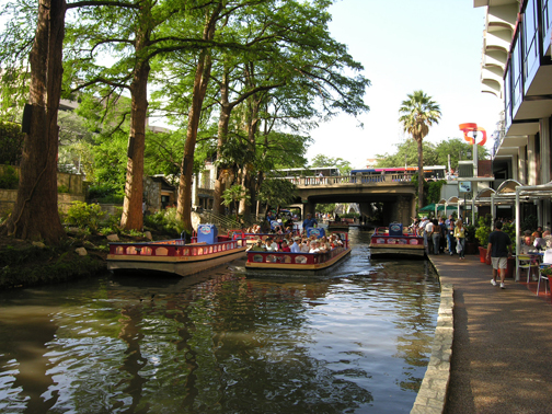
The project currently is thriving, with 1,000 conventions a year in the city and 10 million visitors to San Antonio a year. The Riverwalk area includes not only bridges, walkways and shops, but also boat tours, sidewalk cafes, a connection to a 1,000 room Marriott as well as the Hilton built for the world's fair.
LINKS/REFERENCES"The Best of Texas Highways: The San Antonio Riverwalk." http://www.texashighways.com/riverwalk.htm
"The San Antonio River: A Brief Look at Its Colorful History." http://www.ci.tx.us/pio/riverwalk.htm
"San Antonio Texas Visitor Information." http://www.postnetsa.com/postnet/sanantonio/welcom.html#books
"Virtual San Antonio: Paseo Del Rio." http://numedia.tddc.net/rb
Page Author: Monica Kuhn
Suggested other pages... Physical Strategies Functional Strategies .
